Day 22: Ups and Downs
July 12th
Cascade Lake(179.3)-Horse Creek Pass(189.1)
Mileage: 9.8mi
Campsite Elevation: 10,626ft
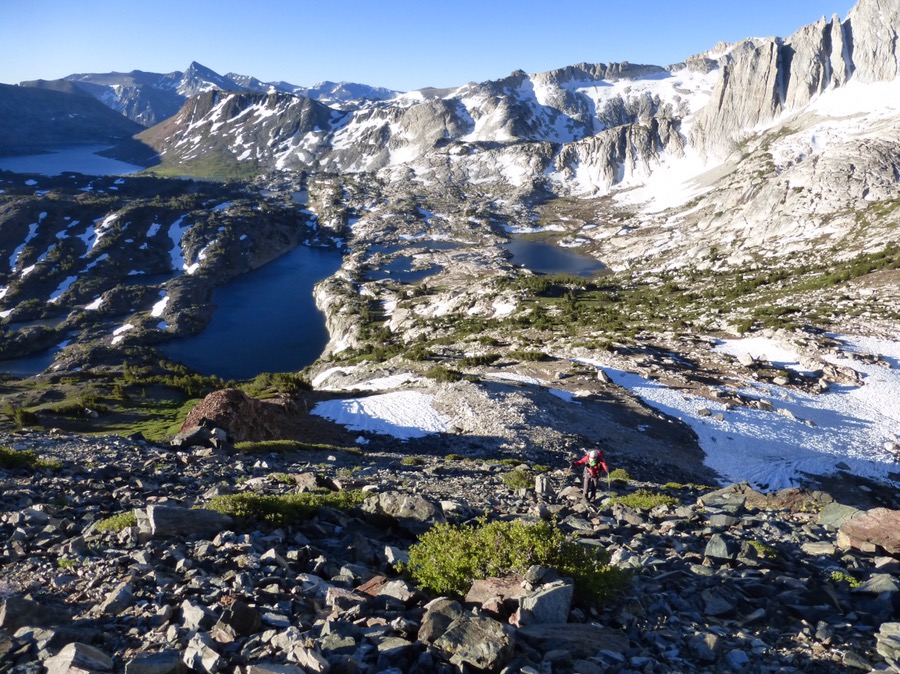
Today was our last full day on trail since we will finish the SHR tomorrow! It packed in plenty of ups and downs. We jumped right into the 1,300ft ascent of Sky Pilot Col this morning. Just around the corner from us, we came upon a couple doing an overnight that came in from a side trail. It’s just really odd to see other people out here and we all found it funny that we were camped so close to one another yet thought we had it all to ourselves. Sky Pilot Col is known as one of the most formidable passed on the SHR, but it ended up not being too bad.
It came in stages. First, a light use trail led up to a small tarn. We thought about heading up here to camp yesterday, but we weren’t sure if there would be camping. There was quite a bit of snow, but there were camp spots up there for anyone wondering.
Why Not hiking up the pass.
Why Not heading up the steep pass.
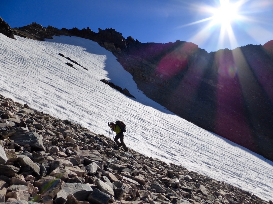
From there, it was large talus, and then scree and dirt on the final part. We were able to dodge the snow still lingering on top. It was so steep and loose that we were using our hands and feet to claw our way up as the scree slid down. In this process, my water bottle fell out of my pack, but Why Not was able to retrieve it. I must have set it down when we got to the top, because a bit later, I realized I didn’t have my water bottle. Doh! I made it this whole trip without losing something major and on the last full day, I lose my water bottle. For the next 24hrs, I’ll use my Platypus and just put the Sawyer Squeeze on the end.
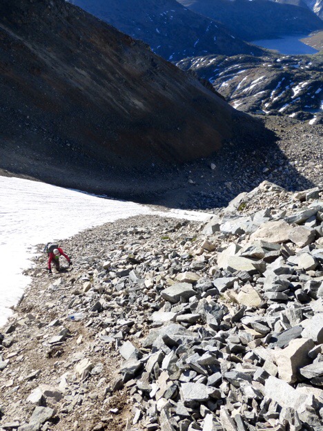
The descent off of Sky Pilot Col can be really taxing with boulders that go on forever. We have been hoping all trip that this one would have snow on the north side and thankfully it did! We were able to cruise over what would have been endless boulders. This was probably the most beneficial the snow has been for us all trip.
We still had some boulders to go over, but it was not for long in between snow fields.
After Sky Pilot Col, we needed to drop down to the floor of Virginia Canyon. Much of the off trail descent was in the forest with tall grass. A very unique experience to the SHR and its alpine granite above the trees. That descent from the top of the pass to the canyon bottom was 2,550ft.
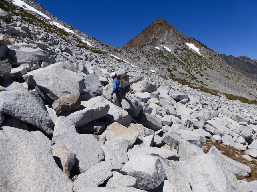
Once at the bottom of Virginia Canyon, it was 2,200ft right back up to Stanton Pass. The south side ascent is fairly straight forward once out of Virginia Canyon. Before the final climb we ate one last lunch next to an alpine lake, Soldier Lake.
There were some medium sized boulders on the way up to Stanton Pass that were time consuming, but nothing like what we knew was waiting for us on the north side…
Rockin’ going up boulders on Stanton Pass.
The top of Stanton Pass first appears simple with a nice green view of Spiller Canyon gradually working up to Horse Creek Pass, but it has one of the sketchiest descents near the top.
Rockin’ is comfortable on the bouldering stuff and exposure and she was super patient taking us (mainly me) step by step through the creepy spots. I was too freaked out to take many photos, but doing some of these things with a pack on is just frightening for me. Photos don’t do it justice. I’m sure Rockin’ and Why Not may have gotten better photos to depict it. I’m just glad it’s over.
Once past the sketchy stuff, it was a regular scramble, boulder, grass combo to the bottom.
We realized we had enough time to head up toward Horse Creek Pass and wanted to camp as close to the top as we could. It was a nice gradual up in a grass filled open valley.
Heading up to Horse Creek Pass, our final pass!
We didn’t intend to, but we ended up coming all the way up the pass to find camping for all of us. It’s a wish come true for all of us that we got to camp at the top of a pass on this trip. Rockin’ has camped on a pass many times, but this is a first for myself and Why Not. A great spot to have our final night.
Today felt like a lot of elevation gain/loss. We were rarely hiking level today with long ups and downs. We calculated it roughly and got 4,161ft of uphill and 3,850ft of downhill over a total of 9.8mi. That’s quite a bit for cross country hiking in one day and we are all going to sleep well tonight. Tomorrow is the last day! We have about 6mi with 3,500ft of downhill to the trailhead where LoveNote is picking us up, yay! Super excited about all of it!


Wow - such a challenging hike - makes me exhausted just reading about it!! You have really overcome some “iffy” stuff - good for you.
For sure! Just after repeated exposure, it has helped, but I sure do love a good trail to meander along:)
Thankfully y’all had the snow on the north side of Sky Pilot Col, because it was endless talus for us going up last year.
Have I mentioned how darn happy I am for y’all to have this experience?! 🙂
Yes, so glad the snow was there! Saved us soo much time and energy both physically and mentally.
Cool stuff, as always, Wired. One thing I have noted in all of your blogging - correct usage of spelling and grammar. It’s such a treat to read and makes it much easier (of course) to comprehend.
Thanks for helping us wannabe hikers experience such coolness.
Oh man, it’s quite the chore, so thank you for noticing Tom. I do have a friend (GoalTech) who is quite prompt at reading over them and catching some of those errors. I’m so proud of the few posts that go up that he doesn’t find a mistake of some sort! I do think that beauty lies in the details, so I tend to be quite thorough, which is a blessing and a curse!
Oooh…I like this comment. 🙂 The only reason I do it is that I know that it bugs Wired as much as it bugs me to have typos or errors on my blog. 🙂
We are totally on the the same page with that!
Add me as appreciative of your team efforts. I would enjoy the content, but you make it so readable.
This trip has been so special, three of my favorite bloggers, going where I will never go (I have been to Mammoth, Yosemite, Tuolumne Meadows, etc.,but definitely not the same experience).
Ah, yay! We tried to think of how to do it as a group, but we each have our own style and way of doing the blogging that we just stuck with what we do. I have to say it is nice to hike with others that blog as they understand when the phone is out and know how great that wifi time can be!
Mercy’s sakes!
Great story Wired!! Really enjoyed the updates as we (wife, myself and a friend) are heading to SHR on July 31st. You guys are hard core to tackle such a route that early in season. We’ve done the section from Humphrey’s Basin to Red’s Meadow. We are really looking forward to doing the first and last sections. Thanks for taking the time to post trip reports as it really helps with the planning for our trip. Have a great summer and we look forward to your post on your remaining hikes for the summer.
Cheers,
Mule, Sista Mule & Night Raven
Oh cool to hear! This is one that is definitely more fun to share with others. Happy that this can be helpful for others.
Erin, great post and photos. And thanks to Goal Tech. Very cool to keep the blog grammatically correct and a pleasure to read.
You are almost there!