January 26th
Locke Stream Hut(1322)-Arthur’s Pass(1347)*
Mileage: 26mi/41.8km
*Had to do the official 20km road walk alternate because the Deception River was too high to go up Deception Valley.

Elevation chart courtesy of Guthook Hikes Te Araroa App. Doesn’t include 12mi/20km road walk to Arthur’s Pass with 2000ft/600m gain.
Welp, today was yet another day of rain. A full day of rain. Like all day, without a break, rain. Did I mention that it rained!? I’ve hiked in plenty of rain, but it’s rare to get a full 12-14hrs of hiking in rain, and that’s happened twice in the last five days of hiking. We’ve had seven straight days of hiking with completely soaked feet the whole day with how much standing water there is. Yes, it wears on a person after that many days, but what else can we do about it. There’s just no avoiding it and we have to just keep moving and accept it as the new normal. Again, this does not seem abnormal for what people experience in this section. It’s river valleys and it’s New Zealand. Not ideal for trying to thru-hike. Two pros for today are that there were alternates and options so we probably wouldn’t be blocked in, and I’m glad it was a steady 50F/10C so standing still wasn’t too uncomfortable and I wasn’t chilled to my core.
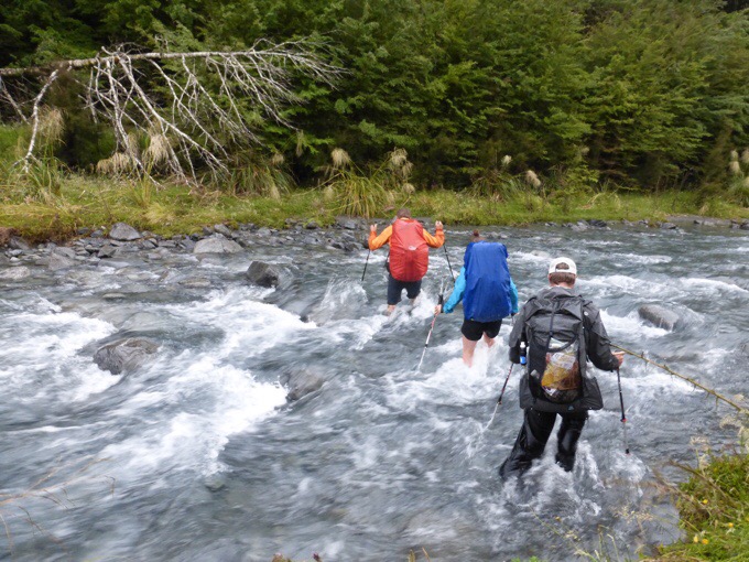
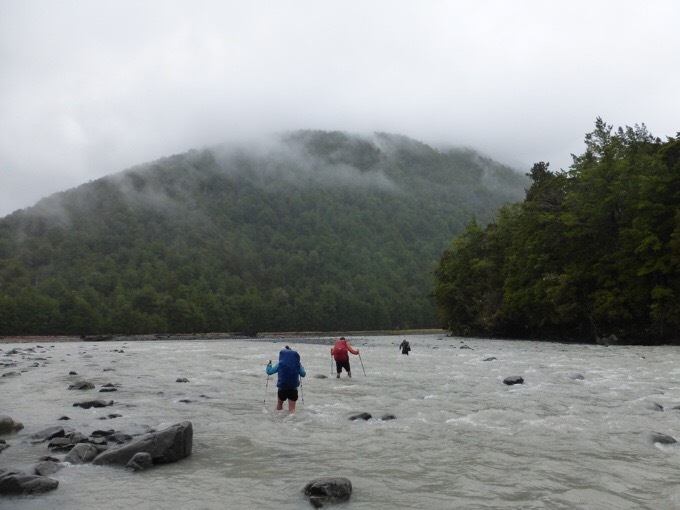
We got started at 6:40am with a light mist falling and immediately had our first crossing or the Taramakau River. Since it was higher up, we knew this one wouldn’t be as bad as the major one down valley later in the day. Still, it took some looking around for me to find a comfortable spot. Griggs went right in and through something deeper than I could handle. I found something more my size about fifty meters downstream. Steve and Amelie also approached by then and crossed where I did. The four of us stuck together most of the day to do the crossings together.

Griggs crossing the Taramakau.

Where Steve, Amelie, and I crossed.
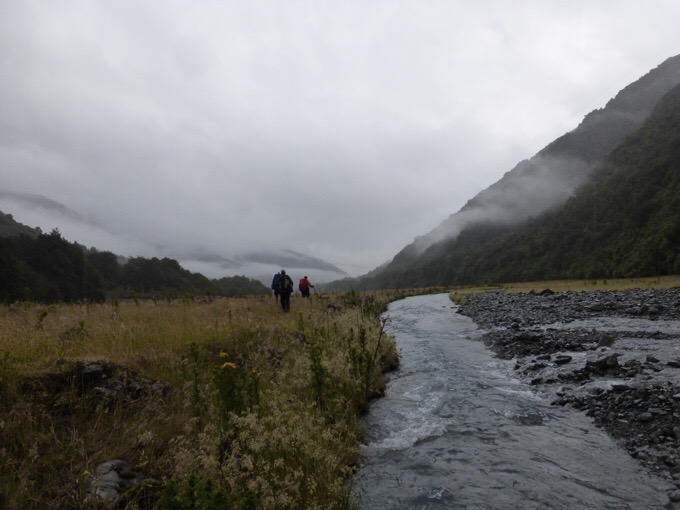
As rain varied from mist to steady, it was mostly smooth sailing at a 2.5mi/4km per hour pace to the Kiwi Hut for the first hour and a half. There were some wooded parts or stretches along the riverbank on rocks, but they were fortunately short lived. There were crossings of smaller streams that weren’t dangerous at all. Cold, but not dangerous.

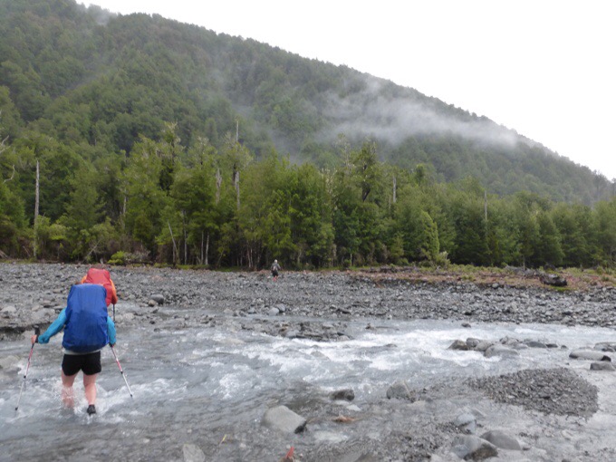
Just after the Kiwi Hut was the Taramakau River crossing. It is suggested that if flow is high that hikers should not cross downstream of the confluence of the Taramakau and Otehake Rivers where the track goes normally. By crossing upstream, it is possible to cross many branches of smaller things and to cross the Taramakau and Otehake before they merge. Fortunately, that worked for us and we found a spot to cross where water was swift, but low, so doable. Our feet were quite cold afterwards as it was wide and took minutes to cross.
Crossing the Othehake River.
Once on the other side, we did have some bush to got through off the bank, but it appears that enough people have done it that way that there is a bit of a path and fortunately, it wasn’t as dense as it looked from the outside. Definitely the way to go if water is high! We did try to cross the Otehake as a group further downstream to avoid the bushwhack, but it was just too deep and swift. I was being brought up off my feet and we chose to go back up where it was shallow and take the brief bushwhack. I’ll take that any day over a scary crossing!

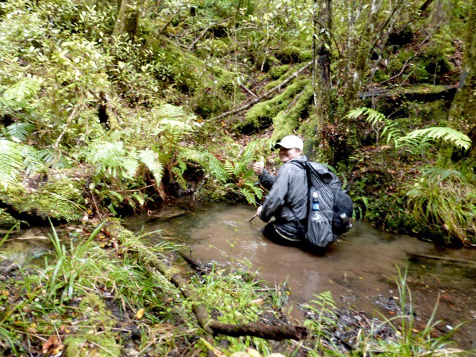
That was unexpectedly deep mud.
We all were relieved it was over and got into a less dense forest where we decided to do a very quick lunch. We all were wet and cold, but not too bad to be able to stop and eat as light rain fell. I don’t know if I’ve ever eaten lunch that quick, but I think we were done and back hiking in about 20mins. No breaks today…
After this, we had some hiking in and out of the forest and riverbank. The official track follows a flood track that is quite beat up and destroyed in the forest, but is above the many branches of the Otira River that couldn’t be crossed today. It was slow going, rain was a bit heavier, and we were just wanting it to be over. We were so close to reaching the Morrison footbridge that led to safety and a road walk!
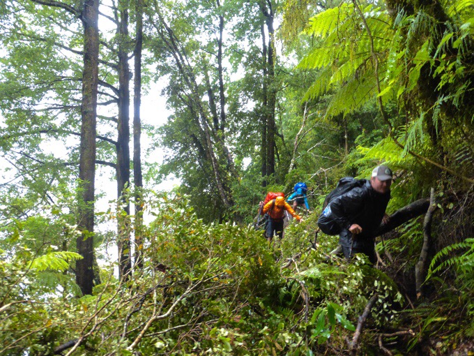
Flood track bushwhacking.
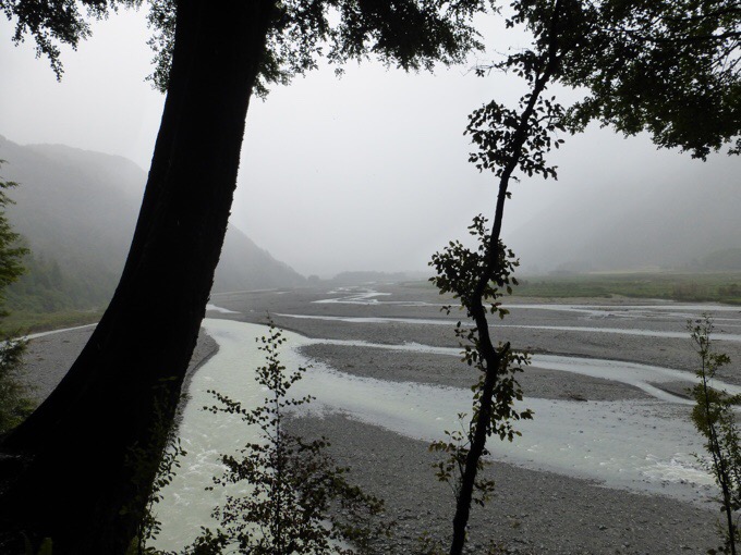
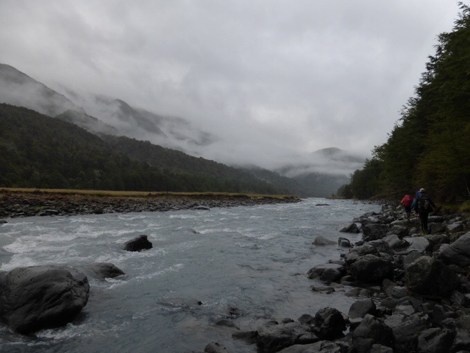
Looking down on the Otira River.
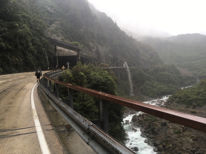
Griggs and I said goodbye to Steve and Amelie and pushed on ahead realizing we could make it to town today if we tried. The TA usually goes up Deception Valley fording the Deception River many times over the next couple days, but we knew it was impassible. The official alternate is to walk the highway for 12mi/20km that parallels it to the next trail town of Arthur’s Pass. We decided to make that happen. We got to the footbridge around 2pm and were so relieved to have the crossings over with. At this point my camera got put away and I used the iPhone that had some fog on the case’s lens at time, but I feel gives the full feeling of this gloomy, rainy, blustery day.
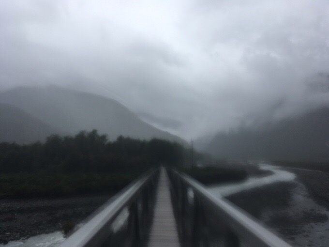
We made it to the Morrison Bridge!
When the weather bomb hit over a week ago, there was a massive spill over the highway that closed it and it just reopened recently. Here’s a photo from the news and a photo of how it looked today with crews still clearing it.

An overhead view of the Arthur’s Pass spill after the weather bomb courtesy of NZ news.
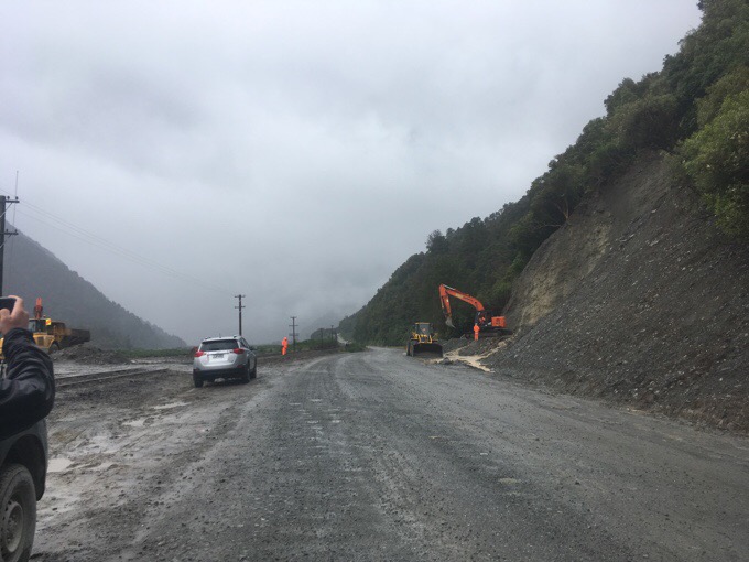
The spill today.
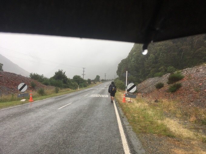
We were fortunate that because of the slip, there was less traffic on the road. There was still plenty, but it was in waves and not as constant. Most seemed to be coming towards us.
After an hour, we came upon a side motel and cafe. We totally took the opportunity to have hot chocolate by the fire. It was sooo tough to leave, but we still had 3hrs in heavy cold rain to Arthur’s Pass. We called the YHA hostel there and got the last two dorm beds, whew!
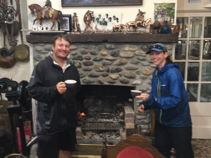
I don’t think I’ve ever enjoyed hot cocoa by a fireplace so much!
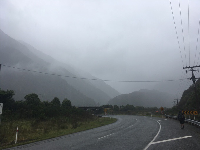
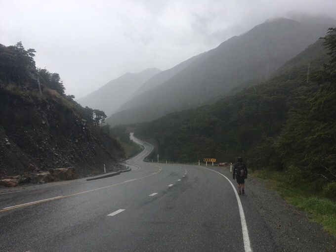
The roadwalk was a consistent uphill that felt eternal after our day and all the rain. We had our headphones and made great pace up the 2000ft/600m climb to the top of the pass. It was quite a scenic and nice walk even in the rain.

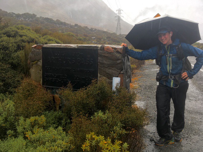
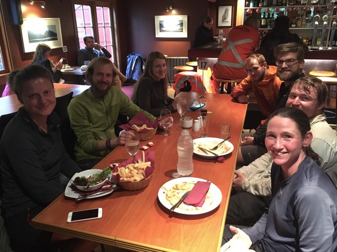
Then it was some nice downhill to the town of Arthur’s Pass. We made it to town around 6pm and one restaurant was open. We have a ton of extra trail food because we had extra for if we got blocked in by the high waters and we both have resupply boxes in town. Still, after the day we had, we were getting a meal! We were total hiker trash and plopped down in front of the fire until our food was ready.
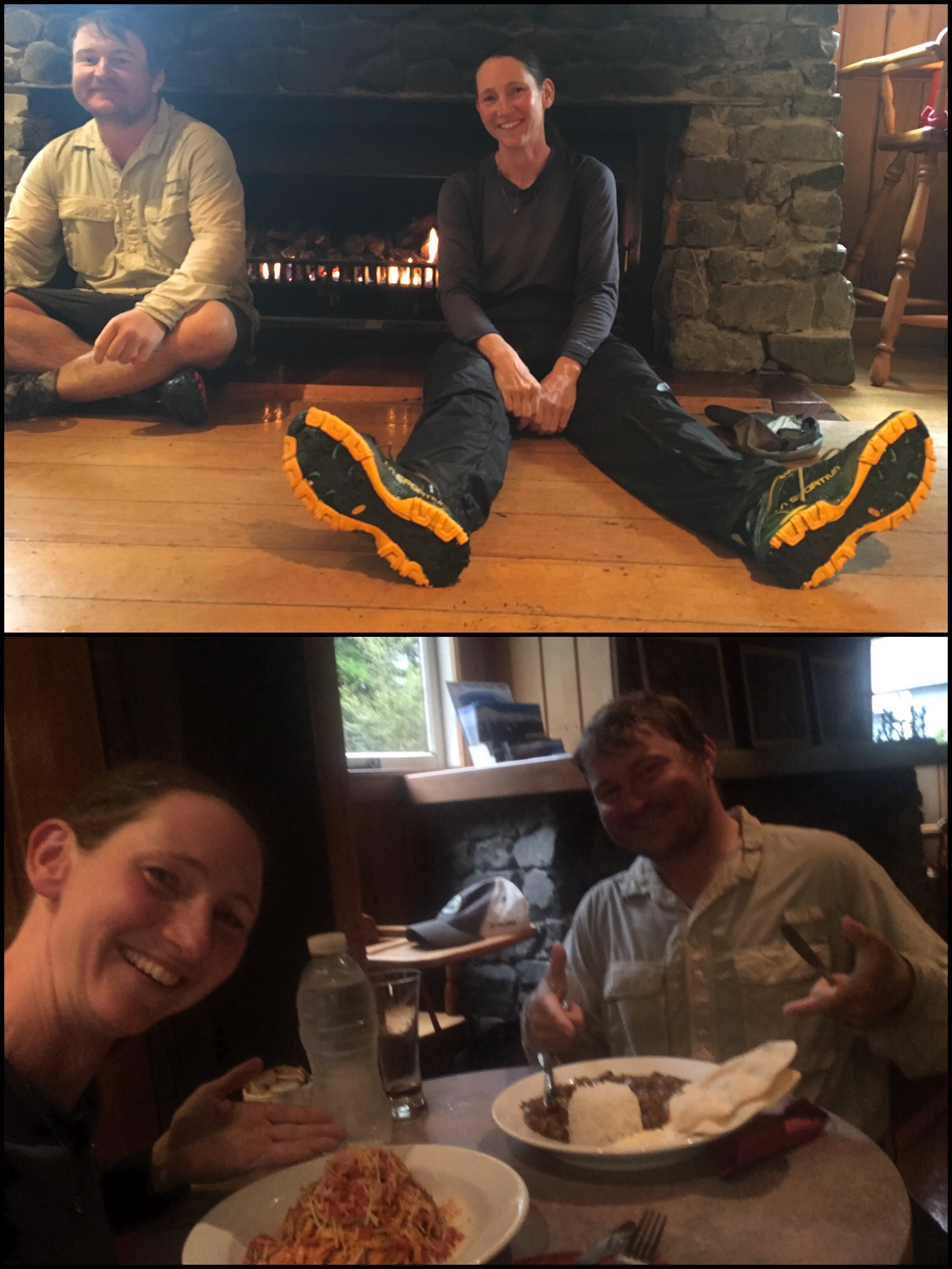
Then other hikers that had been in town on a zero came in! Angelynn who I haven’t see in 40 days! Also, Jan and Jasmin, Sylvan, and Steve. We all made it to town and were happy to have a dry warm place to be.
Clockwise: Angelynn, Sylvan, Jasmine, Steve, Jan, and Griggs.
The Mountain House Hostel is laid out nicely. Wifi was shoddy, but may work in the morning. We are in a dorm room for 8 people and everyone is really quiet. I’m just happy to be inside at this point. There’s no point in washing our clothes, so we threw them in the dryer. They say another dump is expected overnight. Our plan is to leave by noon when the rain should ease and see if we can ford the first river on the next part. If not, we may be waiting it out somewhere before it. Weather looks to be a mixed bag up ahead, but it’s a short stretch to the next town at least. Ok, crossing fingers that the next river is fordable tomorrow!
Like this:
Like Loading...


I dont know any kiwis who would do those crossings without buddying up in side by side river crossing methods, ,,, keep it up and someone may drown, theres already been several drownings this year in rivers…
We’re both really experienced in crossings and know our limits. Griggs can do things I can’t, and I can decide independently. Everything here hasn’t been as challenging as what we’ve both done in the Sierra (except the swollen side streams after the Tarauas). We would do group or buddy crossings if we felt it was necessary, but it hasn’t come to that. These are a lot safer than the Sierra ones.
What a pity it’s been so wet during the Nelson Lakes and Arthurs Pass National Park sections. We as recreational trampers have the luxury of choosing the weather windows but TA hikers don’t have as much flexibility. When you’re crossing a golden field further south in the sun with a warm wind at your back – those gnarly rivers and relentless rain will seem far away….
Please, please take Wayne’s advice about crossing rivers together, linking arms. This is a tried and true way to safely cross NZ rivers and it saves lives!
Hope your foot continues to heal well. Take care 🙂
Thanks for choosing a different route on the Otehake crossing. Sometime those decisions can be tough to make especially in a group. Crazy this rain is but it sure does make for some interesting reading while I’m sitting here warm and dry. For some reason I feel like some hot chocolate… As always, stay safe on your journey..
Admire your tenacity immensely! Can you ask Griggs how he likes his ZPacks Arc Haul? I have one coming to me to try out. Feeling the GG Mariposa will be a bit too small room wise for me for the likely wintry Sierra PCT section this year!
He also used one on the PCT. He likes the comfort a lot, but won’t get the pack again due to durability issues. They guarantee a year and send out a replacement if needed and he saw many replaced on the PCT. Just yesterday we had to stop for awhile to fix some stuff on it. The straps and suspension can have issues. He likes that they replace it, but the stress of dealing with it on trail isn’t worth it for him. He will use MLD Prophet or a Hyperlite Mountian Gear pack for the CDT.
By definition, we’re only getting pictures of the non-buddied crossing attempts, but I am wondering whether you guys are going to try more of the group crossing technique, even though it’s not what you’re used to. It may expand what’s possible on the river crossings.
I guess it was raining really hard. Your shoes are so clean! Hope you have fun with those you’ve landed with.
Admire your tenacity. Does Griggs have a blog? I’m especially interested in his gear list.
No, no blog, but maybe I’ll get him to do a quick gear list cause he’s pretty light!
You´re so tough! Unlike me, because this definitely put me off wanting to do the South Island TA in the future.
Stay safe, hope your foot is OK and the rain moves somewhere else, they could do with some water in different parts of the world.
In 2012/13 it rained three times during my time on the South Island and I was either in a hut or in town to avoid it. Don’t be put off!
Thanks, Phil! It´s nice to hear that. Hope Erin will luck out with the weather and enjoy plenty of dry, warm sunny days.
Man, a couple hikers jumped further south in hopes of drier conditions and still got slammed.
At least one advantage of your current situation is that you don’t have to bother washing your clothes or even washing yourself. silver lining in every cloud.
Oh No!
The Minga/Deception Route was my favourite on the whole trail. Such a bummer to miss that one.
Don´t start the TA to early kids, train well, hike steady and start in January, the later the better the weather gets usually.
Hike on wired!
Of course it was, dang! Maybe Becky will be able to do it and tell me about it or I can hit it after the hike.
Exhausted just reading that Erin.. well done! Time for a hot cocoa I think!
Glad you have other hikers around for those gnarly crossings..
The Minga/Deception trail is part of the TA so I don’t understand why you wouldn’t even give it a go?
You seem critical of people that hitch sections yet you are happy to take an easier option on a road?
l understand there is a lot of bad weather about, but plenty of others have completed the Minga/Deception recently.
Hyoh.
Walking an accepted alternate for safety isn’t tge same as sitting and being driven around or past a portion of a trail, seems to me.
People died trying to go up the Deception river… Wired had made the smartest move considering the conditions.
It is indeed a great highlight of the TA but on a thru hike you gotta make smart moves and potentially miss some stuff…well done Wired
Yep, exactly. I was bummed to miss it as it’s a highlight, so everyone knows I would have done it if it was possible as opposed to a road walk, which is the official alternate for a reason. That area does flood and is impassible at times.
What is with you people ? No matter what Erin does you find a way to criticize her.
Haha, I know. It’s a sad show of how our societal trend seems to be turning. In all my years I’ve never had haters like this. It’s pretty ridiculous and indicative of what’s happening on a larger world stage. People are angry and venting in interesting ways.
Karen, I don’t think the comments were intended to be critical, they were written by people who are concerned for Wired and Grigg’s welfare. They were well meant I’m sure.
Suggesting a safe way to cross a river is good to share – if it means just one person could learn from it, and save themselves from harm – then it was worth the effort.
Wired has assured us she is more than competent at crossing alone and risk-assessing the situation. Her OS experience is considerable and as such, this puts her in a far better position to manage the risks than others.
Unfortunately NZ rivers have a notorious reputation and far too many lives have been lost doing exactly what has been illustrated here. You can understand how upsetting it is for Kiwis to read of another drowning in our mountains.
Complacency has no place in the NZ wilderness.
Good luck to Wired on her journey south.
I’m talking about the dude who took her to task for the choice to avoid an impassible section of trail. But thanks for the lecture
That’s rather unkind… I meant well but misinterpreted your meaning.
Likewise of the comments here, most were written with the best of intentions by people who genuinely care.
It’s quite possible Sam is not familiar with risk-assessment. The Deception is a death trap when in flood.
No one has completed it that I know of since the weather bomb. The river is impassible. Everyone knows I’d be first to do it if it was doable.
most of the trail up the Mingha Deception river is in the riverbed, in rain like this the river is often flooded from side to side, there is often no river flat above water, the riverbed runs into steep hillside with very thick bush thats hard to move through and in places is dangerous to try and traverse because of its massive boulders that block your path and are dangerous to climb around, because of crumbly rock faces. No one has ever done the Deception and Mingha when they are in flood, several have died trying, even at low water they are difficult to cross, if you took one look at the Deception in flood you’d understand why you dont attempt it, the weather is going through in waves, if you get to the deception when its raining your chances of completing it a slim to nill, the road runs parallel to the deception mingha anyway, and its pretty much regarded as an acceptable alternative to the river because it can be a killer… I did the deception at low water and damaged my knee crossing the river and had to be helicoptered out. its the only time i’ve ever injured myself that badly in the mountains.
Hey Wayne, give us an update, what’s the weather up to today? Looks like Erin hasn’t hit the button on her tracking device or she’s stalled at a hut/camping near the trail?
Thank you Wayne. Our decision was a very educated one. It wasn’t physically possible with all that rain to ford the Deception.
Wired, do you use hydropel (or something similar, don’t think they make that anymore) on your feet to prevent maceration? Or is that not an issue? Always wondered how people deal with wet feet for days at a time.
You get used to it buddy and after a certain point..just don t give a f… about it
Somehow our feet are totally fine. They must have adjusted by now. Being able to dry out completely in the huts at night is huge.
I have to add my concern to Wayne’s. The first picture on this page is someone trying to die. I mean no disrespect by that. The rule of thumb is if it’s going faster than you can walk and above your knee it’s too deep and fast cross. You never HAVE to cross a river. you either wait it out, or go much further upstream. It’s never worth sending someone across alone for a photograph. I really strongly recommend you learn the pack grasp river crossing method. I’ve been hiking in NZ conditions for 30 years and there is no technique to compare with the pack grasp. In the picture with 3 people crossing the long river, it is foolishness to cross that alone in those conditions. 50% of deaths in the NZ bush are by drowning.
That photo looks worse than it was and he was comfortable with it. He’s backed out of plenty and knows where his limit is, as do I. The rest were quite shallow and not needed to group up.
Tough times for you, Erin. Be careful. NZ can really deal out challenging weather. For a small country, the variation in terrain and weather is surprising and stunning. Kiwi trampers/hikers are usually skilled, resilient and tough as a result. For “those” who doubt climate change, what you are experiencing is perfect evidence that it is a reality. Stay safe, don’t take risks n those crossing, That first photo is REALLY scary, as Paul notes.
Do take care!
Spoiler alert
Weathers OK, she hit the button a couple of hours later at Lagoon Saddle, might be a bit of rain tomorrow.
Ray Jardine writes that fording rivers is the most dangerous thing that long distance hikers do. Please be careful out there!
SPOILER ALERT
It’s dusk and no location update, may have forgotten the button.
should be somewhere around Lake Coleridge, Two options here after this section, take the diversion about 25 miles along the road to a road bridge, or make a direct crossing over the Rakaia River. No one ever crosses the rakaia at anything other than low water, and its still a difficult crossing, most people opt to take the road. it may be up a bit if the last rain got over the main divide from the west
Sorry, I usually like to push the button in the morning for the public when I’m near roads. I’d done it live at night for the hairy situations for everyone, but like to delay it when it isn’t as pressing. My family does get the live one.
Shit, that is a lot of water!!!
Happy you made it out!!
I miss you alot!
the only photos I’ve ever seen of people going up the Deception is when the river is in low flow, theres a multisport race the Coast to Coast thats been going up the river every year, when it started it tended to be mainly tough nuts doing the event, the river has such a bad reputation, if theres much rain they have always had to divert the event to run up the road, even though they have helicopters flying up and down the course monitoring the race and they will then canoe down the waimakariri gorge in if its flooded from the same rain..
hi Erin,
I’m way behind you on the trail, but enjoy reading your experiences and comparing them to mine.
I just wrote a blog post about this part of the trail…we were so lucky with the weather (unlike you!)
here it is:
https://anaimlesshitchhiker.wordpress.com/2017/03/07/hiking-the-te-araroa-in-new-zealand-part-3/
i’m also enjoying reading your side trips, as they will help me to decide which ones to do!
Lucky, you got to do Deception! I do recommend hitting the side trips if you can.