
Sponsors


Day 50: Harpers Ferry!
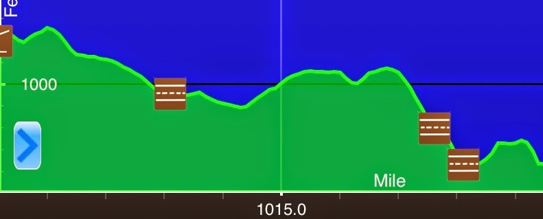
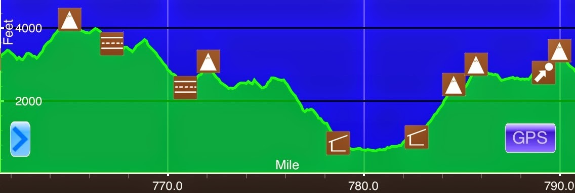
June 5th David Lesser Memorial Shelter(1010.3)-Harpers Ferry (1019.5) West Virginia 9.2mi Elevation chart courtesy of Guthook's AT Hiker app. He has apps for many trails including the PCT and CDT. It rained pretty hard much of the night last night and it was still...
Day 49: Goodbye Virginia!
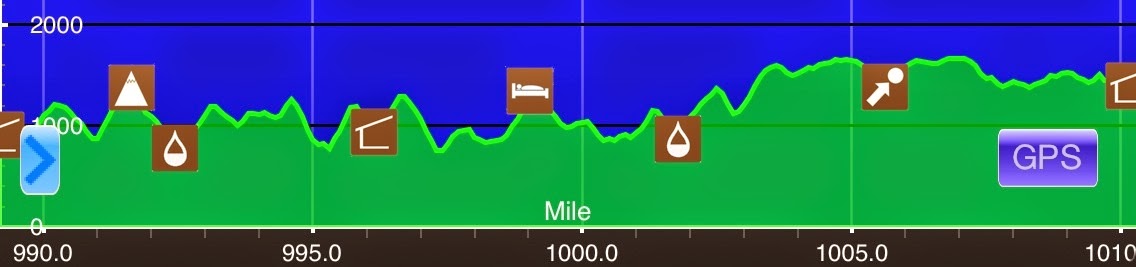
June 4thStream N of Rod Hollow Shelter(989.5)-David Lesser Memorial Shelter(1010.3) Virginia20.8miElevation chart courtesy of Guthook's AT Hiker app. He has apps for many trails including the PCT and CDT. Today was quite a day! There were a lot of significant...
Day 48: The No View Day
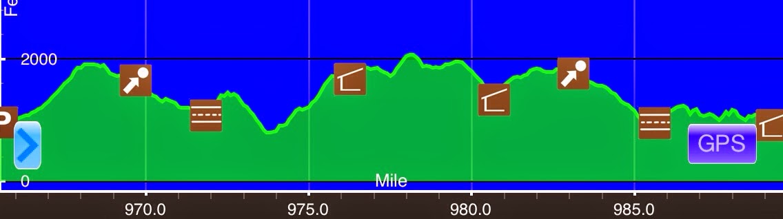
June 3rd US 522/Front Royal(965.6)-Stream N of Rod Hollow Shelter(989.5) Virginia 23.9mi Elevation chart courtesy of Guthook's AT Hiker app. He has apps for many trails including the PCT and CDT. I stayed up way too late last night finishing off the Survivor finale...
Day 47: A Super Nero In Front Royal, VA
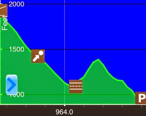
June 2nd Tom Floyd Shelter(962.7)-US 522/Front Royal(965.6) Virginia 2.9mi Elevation chart courtesy of Guthook's AT Hiker app. He has apps for many trails including the PCT and CDT. It was a nice night of sleep and we all got up easily and ready by 7am knowing that we...
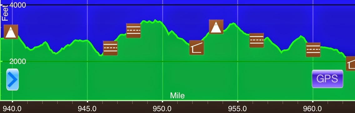
Day 46: Goodbye Shenandoah
June 1st Pass Mtn Hut(939.1)-Tom Floyd Shelter(962.7) Virginia 23.6mi+.2mi side trail=23.8mi Elevation chart courtesy of Guthook's AT Hiker app. He has apps for many trails including the PCT and CDT. After yesterday's big mile day, we weren't sure how energized the...
Day 45: Drafting Off Wired
May 31st Bearfence Mtn Hut(912.3)-Pass Mtn Hut(939.1) Virginia 26.8mi+.3mi side trail=27.1mi Elevation chart courtesy of Guthook's AT Hiker app. He has apps for many trails including the PCT and CDT. So I thought yesterday was a one time occurrence with the Kallin...
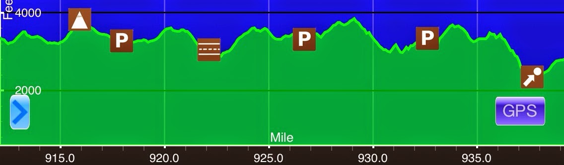
Day 44: Walking With The Kallins
May 30th Pinefield Hut(891.7)-Bearfence Mtn Hut(912.3) Virginia 20.6mi+.2mi side trail=20.8mi Elevation chart courtesy of Guthook's AT Hiker app. He has apps for many trails including the PCT and CDT. Today is my lowest mileage day through Shenandoah. I'm limited in...
Day 43: A Day Of Rain & Fog
May 29th Calf Mtn Shelter(865.5)-Pinefield Hut(891.7) Virginia 26.2mi+.4mi side trail=26.6mi Elevation chart courtesy of Guthook's AT Hiker app. He has apps for many trails including the PCT and CDT. Well, the rain did return on and off last night and seemed to stop...
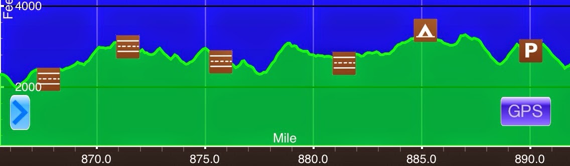
Day 42: Entering Shenandoah National Park
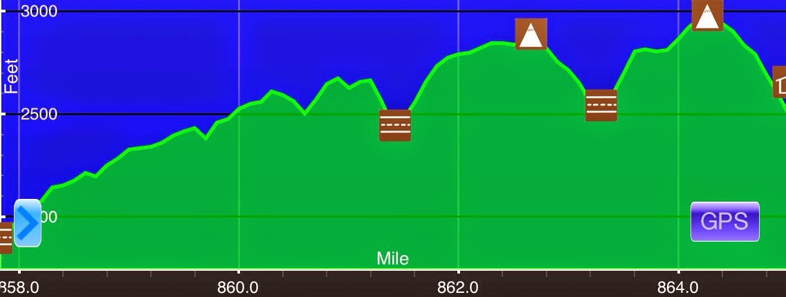
May 28th Rockfish Gap/Waynesboro(857.9)-Calf Mtn Shelter(865.5) Virginia 7.6mi+.3mi side trail=7.9mi Elevation chart courtesy of Guthook's AT Hiker app. He has apps for many trails including the PCT and CDT. I was sooo happy to have a room to myself at the hotel. I...
Day 41: A Half Day To Waynesboro, VA
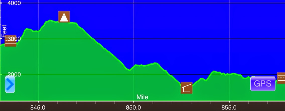
May 27th Cedar Cliffs(843)-Rockfish Gap/Waynesboro(857.9) Virginia 14.9mi Elevation chart courtesy of Guthook's AT Hiker app. He has apps for many trails including the PCT and CDT. I really wanted to get to town today and I saw that rain/thunderstorms were possible...
Day 40: Hikin' Thru It
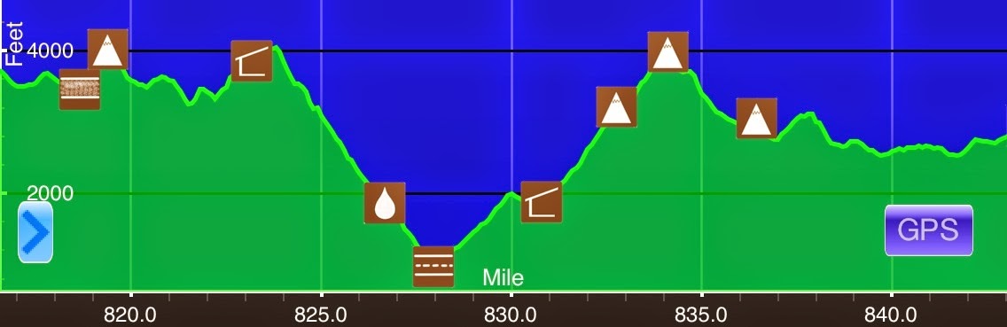
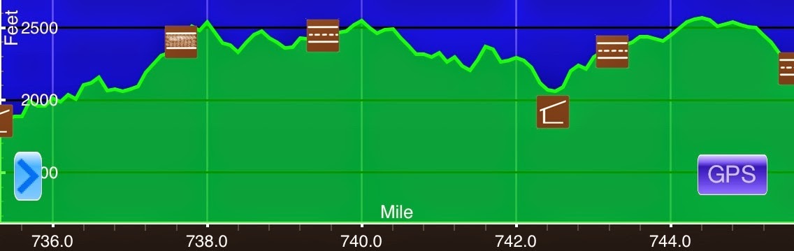
May 26thSeely-Woodworth Shelter(816.6)-Cedar Cliffs(843) Virginia26.4miElevation chart courtesy of Guthook's AT Hiker app. He has apps for many trails including the PCT and CDT. I was better physically today than yesterday, but I'm still just worn out. I'm looking...
Day 39: A Fitting Survivor Day
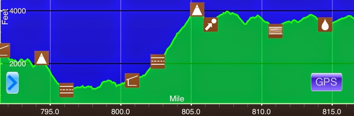
May 25th Punchbowl Shelter(791.3)-Seely-Woodworth Shelter(816.6) Virginia 25.3mi Elevation chart courtesy of Guthook's AT Hiker app. He has apps for many trails including the PCT and CDT. Those who have read my previous blogs know that I'm a Survivor fan and that I...
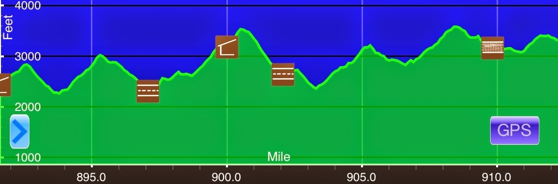
Day 38: Man, It Feels Great To HIKE!
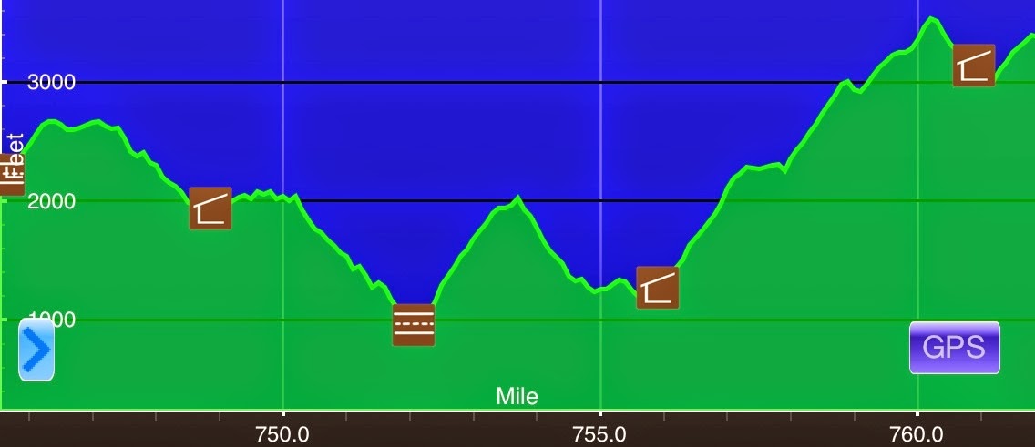
May 24th Black Rock Overlook(761.8)-Punchbowl Shelter(791.3) Virginia 29.5mi Elevation chart courtesy of Guthook's AT Hiker app. He has apps for many trails including the PCT and CDT. It got pretty cool last night and it made for some great sleeping. It also made me...
Day 37: A Pleasant Day
May 23rdBearwallow Gap/VA 43(745.6)-Black Rock Overlook(761.8) Virginia16.2miElevation chart courtesy of Guthook's AT Hiker app. He has apps for many trails including the PCT and CDT. Oh how I enjoy lounging in a hotel room! Ferris and I both woke up around 7am. As we...
Day 36: A Nero To Daleville, VA
May 22nd Wilson Creek Shelter (735.2)-Bearwallow Gap/VA 43(745.6) Virginia 10.4mi Elevation chart courtesy of Guthook's AT Hiker app. He has apps for many trails including the PCT and CDT. It did end up raining last night around 11pm, but it was just a shower. It...